November shaping up wetter in the west; warmer for alpine areas
Published 22 October 2026 by SIMA Forecasting Team. All SIMA News articles.
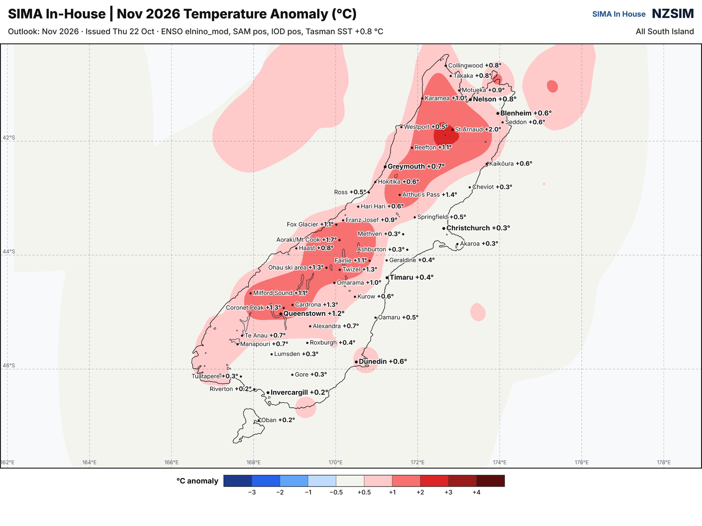
November 2026 November shaping up wetter in the west; warmer for alpine areas November is shaping up warmer than normal across most of the South Island, with the west wetter than usual and the eastern side running a bit
November 2026
November shaping up wetter in the west; warmer for alpine areas
November is shaping up warmer than normal across most of the South Island, with the west wetter than usual and the eastern side running a bit dry. That's the short version, and the rest of this post explains how we got there.
The big driver is still El Niño, and it's a strong one. Near record territory by some measures, and it hasn't finished building yet. For us here that usually means a westerly quarter flow setting up more often than not with W, NW and W/SW days stacking up through the month, rain periodically especially in the West, heaviest about Fiordland and Westland including the Headwaters, and the east sitting in the lee of it all with föhn conditions and drying winds - however we are not expecting significant dry conditions to develop at this stage.
The other piece is the Southern Annular Mode, which we're expecting to sit close to neutral through November. SAM is basically a measure of where the belt of westerly winds and lows sits relative to normal. When it's positive, that belt pulls south toward Antarctica and we get lighter winds and more settled, blocking-type weather over the country. When it's negative, the belt pushes north over us, and we feel the cold southerlies and more frequent fronts. Neutral means neither, the westerlies sit about where they usually do for the time of year, so SAM isn't adding much either way and isn't cancelling out what El Niño is doing. In practice, the El Niño signal gets to run largely unopposed.
Temperatures are more likely than not to be above normal right across the South Island, though the size of that departure varies a lot depending on where you are. The inland alpine areas and the ranges look to be running the warmest against normal likely due to increased cloud cover limiting cooler nights, while the far South and coastal Southland are only marginally up.
Onto rainfall; the split is the classic El Niño one. West of the divide we're expecting above normal totals, and east of it near normal or a little below normal, with large areas of the South Island expected to see near normal rainfall
There is uncertainty, especially with how long the westerly pattern holds in any one stretch. A month like this rarely runs the same way for thirty days straight, you can get a week of hard northwesterlies, then a few quieter days, then a southerly change that undoes the warm run in the east for a bit. The monthly numbers smooth all that out. Expect a varied spring month rather than a uniform one.
If you're farming or on the land in North Canterbury or through the eastern plains, the drying signal is the one worth watching as the month goes on, especially later in the month. On the West Coast it's more about rain days and river levels than anything dramatic.
You can find high resolution zoomable versions of our November Anomaly maps over at nzsim.sima.co.nz
- SIMA Forecasting team
South Island Met Agency is an independent private forecaster and does not issue official government severe weather warnings. For official New Zealand watches and warnings, visit MetService.